Overview
The Dead Sea formed inside a deep tectonic basin along the Dead Sea Transform, where the Arabian Plate moves past the Sinai side of the African Plate. Fault motion created and deepened the basin over millions of years. Water collected in it, earlier lakes expanded and contracted with climate, and evaporation concentrated dissolved salts in the terminal lake that remains today.
The Dead Sea location guide places the basin between Israel and Jordan.
First, the faults made space
The Dead Sea Transform is a left lateral plate boundary. That means the two sides move mainly past one another rather than directly apart. Where major fault strands step and overlap, the crust can stretch and subside, producing what geologists call a pull apart basin.
The Dead Sea Basin is unusually deep because this process continued through several stages. A major structural study dated basin formation to about 15 million years ago or earlier, while later work places much of the main subsidence in the presently active basin around 5 million years ago. Those figures describe different stages, not a simple birthday for the modern lake.
The fault system did not carve one empty hole and immediately fill it with today’s Dead Sea. It created a subsiding basin that accumulated kilometres of sediment and salt while rivers, climate, and earlier lakes kept changing above it. The modern shoreline is the latest surface in a much older geological story.
Read the Dead Sea depth guide to separate the deep geological basin from the much smaller depth of the present water column.
Then a succession of lakes occupied the basin
The modern Dead Sea had predecessors. During the late Pleistocene, the much larger Lake Lisan spread well beyond today’s shoreline. A widely used reconstruction places it roughly between 70,000 and 15,000 years ago, with major changes in level as regional rainfall and runoff varied. Newer dating continues to refine the timing of its final transition.
Lake Lisan left paleoshorelines and layered sediments around the basin. As the regional water balance became drier, the lake retreated. The Holocene Dead Sea developed within the remaining lower part of the depression.
The important idea is not one permanent ancient outline. These were terminal lakes whose size responded strongly to water entering the basin and water lost through evaporation. The Dead Sea size guide explains why the same date rule applies to modern dimensions.
Why the water became so salty
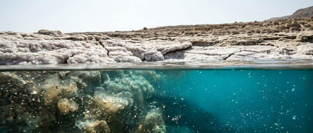
The Dead Sea has no river outlet to an ocean. Water reaches the basin through the Jordan River system, streams, runoff, springs, and groundwater, then leaves mainly through evaporation. Dissolved material remains behind and becomes concentrated.
Repeated changes in lake level, water chemistry, mineral precipitation, and contact with the surrounding rocks produced a brine that is not simply concentrated ocean water. It has its own balance of magnesium, sodium, calcium, potassium, chloride, and other dissolved components.
The closed basin explains the direction of the process: water enters, evaporation removes water, and dissolved salts remain. It does not mean salinity rose at one constant rate for millions of years. Earlier lakes, inflow, climate, mineral precipitation, and human water use all changed the system through time.
The salinity guide covers the modern brine.
Dead Sea versus ocean water explains why the mineral balance differs.
Did plate motion create the low elevation too?
Yes, tectonic subsidence is the foundation of the low basin. The Israel Water Authority recorded the water surface at 441.50 metres below mean sea level on 4 October 2026, and that figure changes as the lake level falls. The Dead Sea elevation guide keeps the latest measurement separate from the ancient tectonic history.
Modern retreat is not caused mainly by the basin suddenly sinking. The Israel Water Authority identifies sharply reduced Jordan and Yarmouk inflow, together with Israeli and Jordanian pumping, as central causes of the recent decline. Evaporation remains part of the water balance. The water level guide follows that current story.
The fault system is still active
The Dead Sea Transform remains an active plate boundary, and earthquakes are part of the region’s geological history. That does not allow a travel page to predict when or where the next damaging event will occur. Visitors should follow current civil defence, park, road, and weather instructions rather than interpret a fault map as a forecast.
Shoreline hazards also have different causes. Many Dead Sea sinkholes form when retreating brine allows fresher groundwater to dissolve buried salt. The Dead Sea environment guide explains why managed access matters today.
Questions visitors ask
How old is the Dead Sea?
There is no single age for every part of the story. Transform motion began in the early Miocene, the basin developed through stages over millions of years, and the modern Holocene lake followed earlier water bodies including Lake Lisan. A date should specify whether it refers to the fault, basin, or lake.
Was the Dead Sea once part of an ocean?
The modern Dead Sea is not a trapped arm of today’s ocean. Its deeper basin record includes older marine and lake phases, thick sediments, and major salt deposits, but the present water body developed as an inland terminal lake. That distinction avoids turning a complex geological history into one simple separation event.
What was Lake Lisan?
Lake Lisan was a late Pleistocene predecessor that occupied a much larger part of the Dead Sea depression. Its shoreline moved repeatedly with regional water balance. Deposits and dated paleoshorelines let geologists reconstruct those changes, although newer research continues to refine the exact timeline.
Why did the Dead Sea become saltier than ordinary seawater?
It is a terminal lake with no outlet to the ocean. Inflow carries dissolved material into the basin, while evaporation removes water and leaves salts behind. Mineral precipitation and changing inflow also affect the final chemistry, so Dead Sea brine is not merely ordinary seawater concentrated by one fixed factor.
Is tectonic activity making the Dead Sea deeper today?
Tectonic processes continue on geological timescales, but the modern visitor-facing change is a falling water surface and retreating shoreline. Maximum water depth can decrease as the surface falls even within a subsiding basin. Use hydrological measurements for current depth and level, not a tectonic rate converted into a travel forecast.