Overview
The Dead Sea water surface measured minus 441.50 metres on 4 October 2026, according to the Israel Water Authority’s monthly dataset. The previous observation in the series was minus 441.48 metres on 30 September 2026. The authority says the level has fallen by roughly one metre a year in recent decades. Every “current level” needs a date because the measurement continues to move.
The Dead Sea size page covers area, length, width and depth separately. This article focuses on elevation, causes and consequences.
Dead Sea water level at a glance
- Latest published observation: minus 441.50 metres on 4 October 2026 (Israel Water Authority).
- Previous observation in the series: minus 441.48 metres on 30 September 2026.
- Official long term context: roughly one metre of decline per year in recent decades.
- Main causes named by the Water Authority: near total loss of Jordan and Yarmouk River inflow plus pumping on the Israeli and Jordanian sides.
- Visible consequences: shoreline retreat, sinkholes and damage to infrastructure and visitor routes.
- The southern hotel beaches front evaporation ponds, not the same moving shoreline as the natural northern basin.
The Israel Water Authority recorded the Dead Sea at minus 441.50 metres on 4 October 2026. That is a dated water surface elevation, not the lake’s depth and not a permanent figure. The same official dataset should be checked again whenever a page claims to show the current level.
What does minus 441.50 metres measure?
It measures the elevation of the water surface relative to mean sea level. The minus sign means the surface is below that reference. It does not mean the water is 441.50 metres deep.
Lake depth is the vertical distance from water surface to lake floor at a particular point. Surface area measures the mapped water footprint. Shoreline distance describes where water meets land. All can shift, but they are different variables and should not be substituted for one another.
The location overview explains the regional geography, while how the Dead Sea formed covers the basin’s geological history. Those pages help explain why the below-sea-level setting exists. They do not replace the monthly gauge.
A Dead Sea water level of minus 441.50 metres describes surface elevation on 4 October 2026. It does not say that the lake is 441 metres deep. Elevation, depth, surface area and shoreline position answer four different questions, so each figure needs its own unit, date and method.
How to compare two water-level readings
First check that both figures describe surface elevation, use the same reference system and come from the same responsible dataset. Then compare the observation dates, not the article publication dates. A news story may be published weeks after the measurement it quotes.
The arithmetic difference between two monthly readings is real within that dataset, but it should not automatically become a new annual rate. A short interval can include seasonal changes and does not replace the authority’s longer observation record. If a figure is rounded, keep that rounding visible rather than adding false decimal precision during comparison.
This is also why an undated statement such as “the Dead Sea is 440 metres below sea level” quickly becomes stale. It can provide orientation, but it cannot serve as the latest measurement. An exact claim needs the value, unit, date and source together.
Why is the Dead Sea level falling?
The Dead Sea is a terminal lake. Water can arrive through rivers, runoff, springs and rainfall, but the basin has no outlet to the ocean. Water leaves mainly through evaporation and human extraction. The level falls when losses exceed inflow.
The Israel Water Authority identifies two main human drivers in its dataset description. First, inflow from the Jordan River and Yarmouk system has been almost completely prevented by dams and upstream water use. Second, Israeli and Jordanian industrial operations pump water for mineral production.
Evaporation is part of the natural system, but calling evaporation the sole cause misses the altered balance. The basin once received much larger river inflows. Reduced replenishment means the same arid setting now produces a sustained deficit.
The Dead Sea environment overview connects water balance with ecology, industry and regional policy.
The salinity article covers the changing brine rather than assuming one concentration remains fixed forever.
How has the level shifted over time?
The Water Authority says official measurements exist from 1900, when the water surface stood near minus 392 metres. It records minus 424 metres in December 2010 and minus 441.50 metres on 4 October 2026. The three points show a long decline whose rate accelerated over the twentieth century.
Historical values should not be treated as though every year fell by exactly the same amount. Seasonal inflow, rainfall, extraction and measurement dates can create short intervals that differ from the long term trend. “Roughly one metre per year in recent decades” is an authority summary, not a rule that predicts the next monthly reading.
The longer Dead Sea history article places modern water policy beside older settlement, travel and industrial phases. That chronology matters because the physical lake has never been a timeless backdrop.
What does the falling level affect?
What happens to the shoreline?
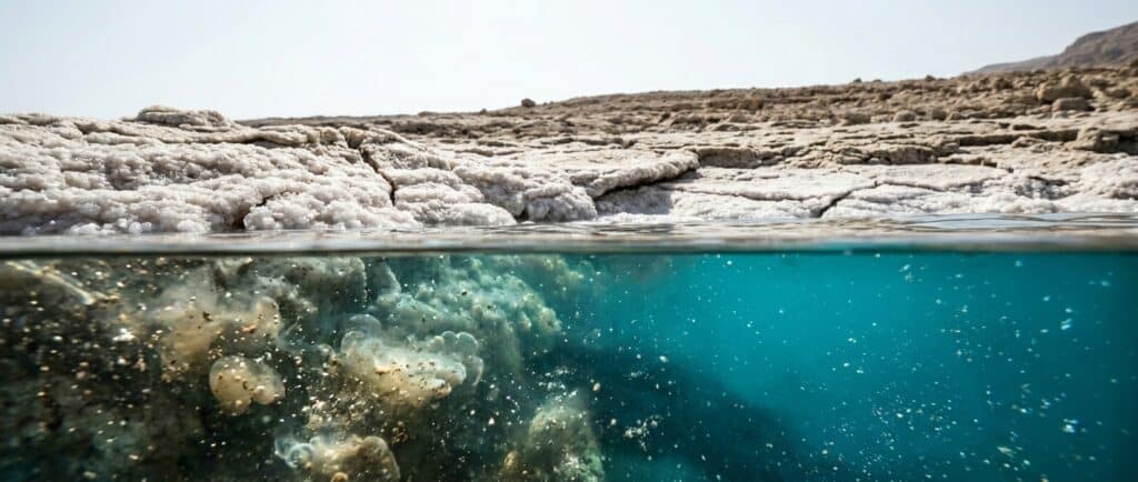
The natural northern basin retreats as the surface drops. Former waterfront facilities can become separated from the water, approach roads may need to move and new ground can be exposed. A map or photograph from an earlier year may therefore show a shoreline route that no longer exists.
In affected areas, fresher groundwater can dissolve a buried salt layer after the brine retreats. Cavities develop underground and the surface can collapse. The Geological Survey of Israel reports more than 6,000 sinkholes and maintains an active monitoring program.
Read the Dead Sea sinkhole page before approaching a receded shoreline. The practical rule is to use a currently open, managed entry and never improvise a path across exposed ground.
Shoreline retreat also alters what visitors see. Salt deposits can appear or disappear as water, temperature and shore conditions shift. The salt formation article explains the science without presenting unstable ground as a photo trail.
What can a map or photograph show?
Maps and photographs are snapshots. They can document where a shoreline, road or building appeared at a known time, but they cannot certify present entry. A wide view may also hide unstable ground between the camera and the water. Use the Dead Sea region map for orientation, then confirm the named destination through a responsible authority or operator.
Before and after images can make retreat easy to see, but comparisons need matching locations and dates. Different viewpoints, lenses and water conditions can exaggerate or conceal the retreat. The monthly gauge supplies a consistent elevation record; site-specific entry still requires a separate live check.
Why do southern beaches look different?
The Ein Bokek and Hamei Zohar hotel district fronts the southern evaporation pond system. Water levels there are managed for industrial and tourism infrastructure, so the immediate shoreline does not behave like the retreating natural northern basin.
That difference explains why a visitor can see maintained southern beaches while reading that the Dead Sea is shrinking. The maintained pond edge is real, and the northern basin decline is also real. They describe different connected parts of the regional system.
Use the Israel beach comparison to distinguish free southern public beaches from paid northern natural-basin venues.
The Israel hotel directory separately records which properties use direct, walking or shuttle beach routes.
How does the decline affect wildlife and water chemistry?
The Dead Sea remains an extreme hypersaline habitat. Microorganisms adapted to high salt can survive, while ordinary fish cannot live in the ambient brine. The water is not sterile, and falling level does not convert it into an ordinary marine ecosystem.
The Dead Sea and ocean comparison explains the density and ion differences.
Why fish do not live in the Dead Sea covers osmoregulation.
What lives in the Dead Sea covers halophilic microorganisms and unusual bloom conditions.
Concentration does not move in a simple straight line with level. Salt can precipitate, water chemistry can stratify and mix, and industrial ponds have their own controls. A new water-level reading cannot by itself calculate today’s salinity.
Who controls the water balance?
No single visitor, city or company controls the entire basin. River diversions, reservoirs, municipal and agricultural water demand, industrial pumping and regional politics involve several authorities and jurisdictions.
Israel controls important water and industrial decisions on its side of the basin. Jordan controls important water and industrial decisions on its side. Palestinian communities and authorities are affected by regional water allocation and shoreline retreat. Industrial operators on both sides also influence withdrawals and pond systems.
Those roles should not be compressed into one slogan or a single-cause blame statement. The Water Authority’s factual baseline is enough for this page: greatly reduced Jordan and Yarmouk inflow plus pumping on the Israeli and Jordanian sides contribute to the decline.
Can a large engineering project save the Dead Sea?
Large conveyance and desalination proposals have been studied for decades. They involve water supply, energy, environmental, cost and political questions that cannot be reduced to “add seawater and refill the lake.” Mixing water from another sea would also create chemical and ecological consequences that need project-specific assessment.
The latest monthly gauge does not show stabilization. That observation does not prove that every future project will fail, but it prevents a proposal from being described as an operating rescue system before implementation and measurable effect.
Readers should separate three questions:
- Does a proposal improve regional drinking-water supply?
- Does it deliver water to the Dead Sea itself?
- Is the delivered volume sufficient to change the long term lake balance?
A project can address one without resolving all three. Use recent government and project documents for any investment, construction or completion claim.
What is the outlook?
The supported near term conclusion is continued concern, not a precise forecast for a future shoreline. The Water Authority describes a decline of roughly one metre per year in recent decades. Future measurements depend on inflow, extraction, rainfall, evaporation and policy decisions.
A projection should name its model and assumptions. This page therefore does not publish a date when the lake will “disappear.” The natural northern basin is very deep in places, and its future shape cannot be reduced to one countdown.
For travel, the actionable result is more immediate. Verify the exact beach, road, park and shoreline route shortly before departure. An old level figure should not determine the route.
What does this mean for planning a visit?
Israel travelers should use the Israel planning hub and select a named managed beach.
A day from the capital can follow the Jerusalem route article.
Coastal travelers can use the Tel Aviv route article.
Jordan travelers should use the Jordan planning hub and confirm the named resort or public beach option on that side. Do not transfer an Israel beach status, transport method or hotel recommendation into the Jordan funnel.
Historical attractions remain separate from shoreline entry. Masada and Ein Gedi Nature Reserve have their own entrances and operating rules. A falling lake level can influence the wider landscape without making every attraction part of one common closure.
Frequently asked questions
What is the current Dead Sea water level?
The latest published observation in this article is minus 441.50 metres on 4 October 2026, from the Israel Water Authority dataset. The value describes surface elevation relative to mean sea level. Check the monthly dataset again before quoting it as current, because the lake continues to move.
How fast is the Dead Sea falling?
The Israel Water Authority says the level has declined by roughly one metre a year in recent decades. That is a long term summary, not a promise that every calendar year or month changes by exactly the same amount. Rainfall, inflow, extraction and measurement date affect shorter intervals.
Is the Dead Sea 441 metres deep?
No. Minus 441.50 metres is the water surface elevation on 4 October 2026. Depth measures the distance from that surface to the lake floor at a specific point. Surface elevation, water depth, mapped area and shoreline location are different measurements and must not share one number.
Why is Ein Bokek still beside water if the Dead Sea is shrinking?
Ein Bokek fronts the southern evaporation pond system, whose water edge is managed for industrial and tourism infrastructure. The retreating natural northern basin behaves differently. A maintained southern beach therefore does not disprove the measured decline of the natural lake or the closure of former northern shore access points.
Will the Dead Sea disappear?
The lake is shrinking, but a precise disappearance date would require a defined model and assumptions about future inflow, extraction, evaporation and policy. No defensible countdown is currently available. The level continues to fall, and the shoreline and route consequences remain serious for travelers and communities.
Is climate change the main cause?
Climate can affect evaporation and regional water availability, but the Water Authority identifies greatly reduced Jordan and Yarmouk inflow plus Israeli and Jordanian pumping as the main explanation. Describing the decline as climate change alone would omit the major human changes to the basin’s water balance.