Background and Geological Context
The Dead Sea occupies the lowest exposed land surface on Earth, sitting approximately 439 meters below sea level within the Jordan Rift Valley. The rift valley sits along a tectonic boundary where the African and Arabian plates are sliding past each other along a transform fault at roughly 4 to 6 millimeters per year. Localized transtensional pull-apart zones along this transform system created the structural depression of the Dead Sea basin. Combined with an arid climate where evaporation vastly exceeds freshwater inflow, this geological setting has produced a terminal lake with no outlet and an extraordinary mineral concentration.
Dead Sea water contains approximately 34.2% dissolved minerals by weight, compared to roughly 3.5% in the open ocean. This extreme concentration is not uniform across mineral species. The brine is dominated by magnesium chloride, potassium chloride, and sodium chloride, with notable concentrations of calcium and bromine. Unlike ocean water, where sodium chloride accounts for the vast majority of salinity, the Dead Sea is the only major body of water on Earth where magnesium concentrations exceed those of sodium. Dead Sea water contains a highly concentrated mix of dissolved ions, primarily magnesium, sodium, calcium, potassium, chloride, and bromide, characterized by extreme concentrations and ratios not found in standard marine environments (Nissenbaum, 1975; Krumgalz and Millero, 1982).
The Dead Sea’s mineral inventory has been accumulating for millions of years. Geologists trace the origin of the basin to remnants of the ancient Tethys Sea, concentrated over geological time through evaporation. Ongoing input from surrounding geology, including mineral-rich springs and runoff from the Judean Desert and Moab Mountains, continues to add to the brine’s complexity. Steinhorn (1983) demonstrated in situ halite precipitation directly from this brine, confirming that the Dead Sea’s chemistry routinely exceeds the saturation threshold under ambient conditions. The result is a supersaturated solution that sits permanently at or near the point of spontaneous salt crystallization.
Dead Sea water holds approximately 34.2% dissolved minerals by weight, a concentration roughly ten times higher than the open ocean and close to the theoretical maximum at which sodium chloride crystallizes spontaneously from solution. This chemical state is the direct driver of all visible salt formation processes along the shoreline and lakebed.
How Dead Sea Salt Formations Develop
Evaporative Crystallization at the Shoreline
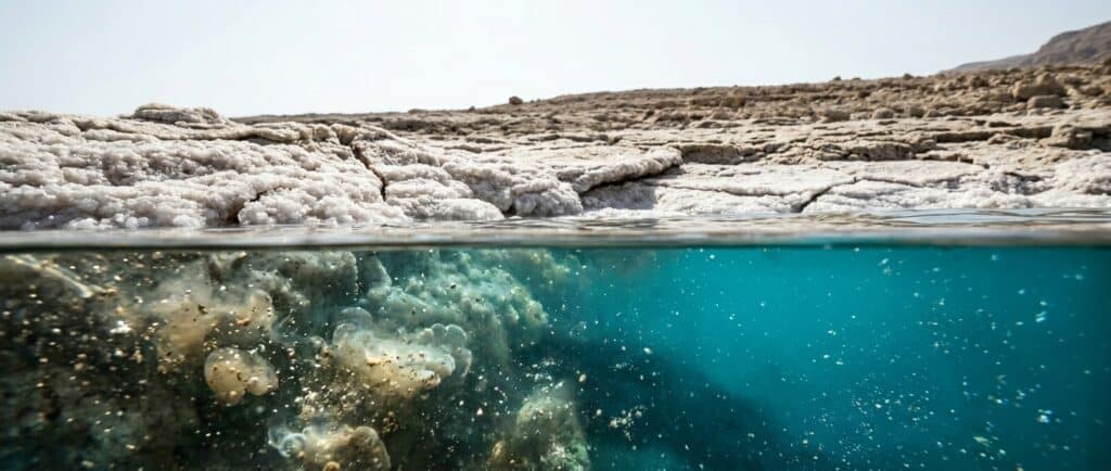
The most widely observed formation mechanism is direct evaporative crystallization. As brine at the lake’s surface and shoreline loses water to the intense desert heat, the dissolved mineral concentration rises above saturation. In the overarching evaporite precipitation sequence, less soluble minerals such as calcium carbonate and calcium sulfate (gypsum) reach saturation before halite. However, halite dominates the visible surface formations because of the overwhelmingly high concentration of sodium and chloride ions in the current hypersaline brine: the sheer volume of NaCl in solution means that once it reaches saturation it precipitates in far greater mass than the minor carbonate and sulfate phases.
This process is continuous. On a warm day, visible crystalline deposits can form within hours on wet surfaces near the waterline. Over days and weeks, these crusts thicken into centimeter-scale layers. Rocks and pebbles become entirely encased in white halite, eventually forming the characteristic salt-coated shoreline terrain that is visible throughout the Dead Sea basin.
The crystallization is not limited to sodium chloride alone. Depending on local brine concentration and temperature, calcium carbonate, gypsum (calcium sulfate dihydrate), and minor quantities of carnallite (potassium magnesium chloride) may co-precipitate. Halite remains the overwhelmingly dominant visible surface mineral because sodium and chloride together constitute the largest share of the brine’s dissolved ion load, producing a proportionally greater crystalline mass than minor mineral phases once saturation is crossed.
“Salt Snow” and Lakebed Deposition
Research by Gertman and Hecht (2002), published in the Journal of Marine Systems, documented a phenomenon known as “double diffusion” at the Dead Sea’s summer thermocline. During the summer months, the lake stratifies into a warm upper layer and a cooler deep layer separated by a thermocline at approximately 25 to 28 meters depth. Gavrieli (1997) documented the long-term halite deposition record from 1960 to 1993, establishing the seasonal and annual accumulation patterns that underpin current understanding of lakebed formation rates.
At this boundary, warm saline water from the upper layer descends and cools rapidly. The cooling reduces the brine’s capacity to hold dissolved salts in solution, triggering spontaneous halite precipitation. The resulting fine crystals fall slowly through the water column in a process researchers have described as “salt snow.” Over a summer season, this mechanism deposits approximately 10 centimeters of halite onto the lakebed.
The lakebed accumulation follows a seasonal rhythm informed by the brine’s physical chemistry. Because halite solubility decreases as water temperature drops, winter cooling of the water column actually drives the most intense period of halite crystallization and lakebed deposition. During years when the lake undergoes complete vertical mixing (holomixis), the cooling of the entire water column triggers substantial additional halite precipitation that augments rather than reverses the summer accumulation. The resulting layered sedimentary sequences, called varved deposits with alternating summer and winter halite bands, provide researchers with a chronological archive of the lake’s hydrological history.
During summer months, a process of double diffusion at the Dead Sea's thermocline causes warm brine to cool and precipitate fine halite crystals that fall through the water column as "salt snow," depositing approximately 10 centimeters of crystalline material onto the lakebed annually before partial dissolution during winter mixing cycles.
Water-Level Decline and Exposed Formation Terrain
The most dramatically visible salt formations are those exposed by the lake’s ongoing water-level decline. The Dead Sea has dropped nearly 50 meters since 1930, from roughly 390 meters below sea level to approximately 440 meters below sea level by the mid-2020s. Since 2001, the rate of decline has exceeded 1 meter per year. Industrial water extraction for potash and chemical production by operations on both the Israeli and Jordanian sides accounts for a significant portion of this loss, alongside reduced freshwater inflow from the Jordan River.
As the water retreats, previously submerged terrain is exposed. This newly exposed lakebed and former shoreline carry substantial salt deposits: halite crusts, salt-encrusted sediment, and in some areas, pillar-like structures where salt has accumulated around a central nucleus over extended periods. These pillars, sometimes reaching several meters in height, form through a combination of capillary brine movement and sequential evaporative deposition. They are among the most photographed geological features at the Dead Sea.
The exposed terrain is geochemically unstable. Freshwater intrusion from rain events or springs can dissolve the salt matrix, contributing to the formation of sinkholes that have become a documented hazard in the Ein Bokek area and other parts of the western shoreline. According to recent monitoring data, more than 6,000 sinkholes have been recorded along the western shore of the Dead Sea, a rapidly accelerating hazard that has been extensively studied since early foundational research (Closson and Karaki, 2009). The sinkholes form when freshwater encounters salt layers beneath the surface, dissolving them and creating subsurface voids that eventually collapse.
The Dead Sea water level has declined approximately 50 meters since 1930, exposing former lakebed terrain that carries thick halite crusts, salt-encrusted rock structures, and pillar formations. The current rate of decline exceeds 1 meter per year, continuously revealing new geological surfaces and altering the visible salt formation landscape at a pace observable within a single decade.
The Southern Basin: Evaporation Pond Formations
The Dead Sea’s southern basin presents a distinct formation environment. Since the 1980s, the southern basin has been entirely converted into industrial evaporation ponds operated by ICL Dead Sea Works (Israel) and Arab Potash Company (Jordan). These operations extract approximately 3.8 million tons of potash annually, along with bromine, magnesium, and other minerals.
The managed evaporation within these ponds generates accelerated salt formation on a large scale. As brine is pumped between ponds at controlled densities, halite and carnallite (a potassium-magnesium chloride, KMgCl3 x 6H2O) precipitate in geometric patterns. Sylvite (potassium chloride) does not precipitate directly from this magnesium-rich brine; the harvested carnallite is subsequently processed in industrial facilities to separate the magnesium and yield potash (sylvite). Aerial and satellite imagery of the southern basin reveals rectangular fields of white and pastel crystalline deposits in cyan, turquoise, and white hues produced by the varying mineral composition of each pond stage. These formations are among the most visually distinctive human-modified geological landscapes on Earth, though they are not accessible to visitors due to industrial operation requirements.
Where to Find Dead Sea Salt Formations
The following locations represent the primary accessible sites for observing Dead Sea salt formations. Conditions at each site change with the season, with water level fluctuations, and with precipitation events. The formations described are typical observations; visitors should expect variation.
Ein Bokek Shoreline (Israel)
Ein Bokek, situated on the Israeli western shoreline of the northern basin, is the most visited Dead Sea resort area. The beach access zones here provide direct exposure to active halite crystallization. Rocks, wooden structures, and any objects near the waterline are typically coated in white halite crusts, visibly demonstrating the continuous evaporative deposition process. Walking toward the receding waterline from older resort infrastructure reveals generational layers of salt deposition, with older exposed terrain carrying thicker and more complex encrusted formations.
The area immediately south of the main Ein Bokek beach complex includes sections of exposed former lakebed terrain where salt pillar structures are periodically observable, particularly following periods of low water levels. Access conditions vary seasonally; the summer low-water period typically exposes the greatest extent of formation terrain. Visitors should exercise caution, as the terrain is uneven and sinkholes have been documented in the broader region.
Amman Beach and Surrounding Shoreline (Jordan)
On the Jordanian eastern shore, Amman Beach is the primary public access point. The salt formation characteristics here are comparable to those on the Israeli side: active shoreline crusting, halite-coated rocks and debris, and exposed terrain carrying crystalline deposits from former water coverage. The receding waterline is evident from the contrast between the current shoreline and the older, salt-stained cliffs and terrain several meters inland.
The Jordanian shoreline in general has received less tourist infrastructure development than the Israeli side, which means some areas to the north and south of Amman Beach offer less managed but potentially more extensive exposed formation terrain. Visitors interested in formation geology should note that the accessible shoreline is relatively narrow in many areas due to steep topography descending from the Moab plateau.
Northern Basin Receding Shoreline
The northern basin retains the Dead Sea’s natural hydrological character. As the primary water body continues to recede, the exposed terrain along the northern basin perimeter carries increasingly complex geological formations. Salt pillars, crusted sediment fields, and exposed lakebed rock platforms are documented features of this zone. Some of the most photographed salt pillar formations are located in areas north of Ein Bokek that were previously submerged within living memory.
These areas are accessible primarily by off-road vehicle or guided geological tour. The terrain is remote in sections, and the unstable sinkhole risk means that visitors should remain on documented paths and avoid areas with visibly hollow or cracked surface deposits. Guided geological and environmental tours departing from Ein Bokek and from Masada include northern basin formation areas in their routes during appropriate seasons (approximately October through May, outside the peak summer heat).
Mount Sodom (Har Sedom)
Mount Sodom, situated at the southwestern end of the Dead Sea on the Israeli side, is an unusual geological feature composed almost entirely of halite and marl. The mountain is approximately 11 kilometers long and up to 5 kilometers wide, rising approximately 230 meters above the surrounding terrain. Unlike the shoreline formations produced by recent evaporation, Mount Sodom represents a massive ancient salt diapir: a geological intrusion where salt deposits from the Sedom Formation, estimated to be several million years old, have been pushed upward through overlying sediment by buoyancy and tectonic pressure.
The mountain contains cave systems formed by freshwater dissolution of the halite mass, including Malham Cave, which is among the longest salt caves in the world at approximately 10 kilometers in length (though access is restricted to authorized research teams and specialist guided expeditions). The external surfaces of Mount Sodom display exposed halite cliffs, salt solution channels, and dissolution features. Guided hiking tours of the mountain’s lower slopes are available from the Ein Bokek resort area and represent the most accessible location for observing ancient large-scale salt geology in the Dead Sea region.
Mineral Composition of Dead Sea Salt Formations
The mineral composition of Dead Sea salt formations reflects the brine chemistry from which they precipitate. Al Bawab et al. (2018) provide a comprehensive characterization of the physical, chemical, and mineralogical properties of Dead Sea salts and mud. The primary minerals present in surface formations are as follows:
| Mineral / Compound | Significance in Formations |
|---|---|
| Halite (NaCl) | Dominant surface crust mineral; first to crystallize; forms white coatings on all exposed surfaces |
| Carnallite (KMgCl3 x 6H2O) | Potassium-magnesium chloride; precipitates at higher brine concentrations; contributes to deeper lakebed deposits |
| Gypsum (CaSO4 x 2H2O) | Minor component; forms small crystals within sediment; indicates sulfate availability from runoff or ancient evaporites |
| Aragonite / Calcite (CaCO3) | Calcium carbonate phases; co-precipitate in warmer periods; present in layered lakebed sequences |
| Magnesium Chloride (MgCl2) | Remains in solution longer than NaCl; enriches residual brines; influences crystal habit of co-precipitating minerals |
The Dead Sea’s brine chemistry differs fundamentally from ocean water in one key respect: magnesium concentrations of approximately 46 grams per liter exceed sodium concentrations of approximately 36.5 grams per liter. This inversion affects the sequence and texture of salt crystallization, producing formations with a different physical character from those in standard marine evaporite environments.
Current Developments and Environmental Context
The accelerating decline of Dead Sea water levels is the single most consequential factor shaping salt formation geography. The water level stood at approximately 390 meters below sea level in 1930. By 2025, monitoring stations recorded levels of approximately 439.78 meters below sea level, a net decline of nearly 50 meters. Salinity has correspondingly increased from approximately 225 grams per kilogram in the 1950s to approximately 342 grams per kilogram by 2011 (Khlaifat et al., 2020), a 52% increase in mineral concentration within six decades.
This concentration increase has two opposing effects on surface salt formations. On one hand, rising brine salinity makes spontaneous halite crystallization more frequent and faster, producing more extensive surface crusting. On the other hand, the retreating waterline continuously moves the active evaporation zone, leaving older formations stranded inland where they are subject to weathering and freshwater dissolution during rain events. The net effect is a dynamic geological landscape that changes measurably from year to year.
Regional and international stakeholders have explored various proposals to address water level decline, including the long-discussed Red Sea-Dead Sea Canal or conduit project, which would transfer water from the Red Sea to the Dead Sea via Jordan. As of the publication date of this article, no such project has reached implementation. The geological and ecological implications of large-scale freshwater or brackish water introduction to the Dead Sea system remain subjects of ongoing scientific investigation and policy discussion.
The Dead Sea's water level has fallen approximately 50 meters since 1930, reaching approximately 439.78 meters below sea level by 2025. Brine salinity correspondingly increased by an estimated 52% between the 1950s and 2011, accelerating shoreline salt crystallization while exposing ever-larger areas of formerly submerged, salt-encrusted terrain.
Stakeholder Perspectives on Salt Formation Access and Conservation
The geological spectacle of Dead Sea salt formations intersects with multiple stakeholder interests across the region.
Tourism Authorities
Tourism operators on both the Israeli and Jordanian sides have incorporated salt formation viewing into their destination promotion. Salt pillars and crystalline shoreline terrain appear regularly in official destination photography. Both the Israel Nature and Parks Authority and the Jordan Tourism Board have documented the formations as notable natural features. Access management varies: some areas with concentrated formations are designated as nature reserves or protected zones, while others remain unmanaged and freely accessible.
Scientific Research Community
Geologists, hydrologists, and geochemists from Israeli, Jordanian, and international institutions have studied Dead Sea salt formations as primary evidence of the lake’s changing hydrological state. Research from institutions including the Hebrew University of Jerusalem, the Geological Survey of Israel, and the Royal Scientific Society of Jordan has documented formation rates, mineral sequences, and the relationship between water-level change and geological evolution. The scientific community consistently frames the accelerating formation exposure as evidence of an environmental system under significant anthropogenic and climatic stress.
Industrial Operators
ICL Dead Sea Works (Israel) and Arab Potash Company (Jordan) operate in the southern basin and are significant contributors to water depletion through brine extraction and evaporation pond operations. Both companies have acknowledged the water-level issue and have participated in various technical studies regarding potential interventions. Their operations also produce salt formations on a large scale within the managed pond environment, representing a different category of anthropogenically accelerated crystallization distinct from the natural geological processes in the northern basin.
Strategic and Regional Implications
The continuing exposure of new salt formation terrain has ambiguous implications for visitors and for the broader ecosystem. From a visitor perspective, more extensive exposed formation terrain can enhance the geological spectacle. The visual drama of salt pillars, encrusted rock platforms, and crystalline lakebed surfaces increases as water levels fall and new terrain is revealed. Formation sites that did not exist a decade ago are now accessible features of the landscape.
From an ecological and geotechnical perspective, the same processes carry significant risks. The sinkhole network documented on the western shore, estimated to exceed 6,000 discrete features, is a direct consequence of the same hydrological changes that produce the visible salt formations. Freshwater from springs and percolation encounters salt layers deposited during higher lake-level periods, dissolves them, and creates subsurface voids. Visitors who venture into unmanaged shoreline terrain, particularly where the surface shows signs of crystalline crust over hollow ground, face genuine safety risks. All relevant tourist authorities recommend remaining on designated paths and avoiding unmanaged shoreline terrain.
The long-term future of Dead Sea salt formations depends on whether the lake’s water level stabilizes, continues to fall, or is artificially supplemented. Each scenario produces different formation trajectories. Continued decline extends the formation zone further but increases sinkhole risk. Stabilization would allow existing formations to consolidate and weather in place. Large-scale water introduction from an external source would redissolve a portion of the existing surface formations and introduce new mineral chemistry to the crystallization environment. The geological outcome of any such intervention remains an open scientific question.
FAQs
What are Dead Sea salt formations made of?
Dead Sea salt formations consist primarily of halite (sodium chloride, NaCl), which is the first mineral to crystallize as the lake’s supersaturated brine loses water through evaporation. Secondary minerals including carnallite (a potassium-magnesium chloride), gypsum, and calcium carbonate phases are present in smaller quantities, particularly in lakebed deposits and older geological formations. The exact mineral mix at any specific location depends on local brine concentration, temperature, and the age of the deposit.
Why does the Dead Sea have such extensive salt formations?
The Dead Sea’s brine is near or at saturation with respect to halite under ambient conditions. At 34.2% mineral concentration, roughly ten times the salinity of the open ocean, the water sits permanently at the threshold of spontaneous crystallization. Any reduction in water volume through evaporation triggers immediate precipitation of halite onto available surfaces. The extreme aridity and heat of the Jordan Rift Valley, combined with the lake’s terminal (no-outlet) character, ensure continuous and rapid evaporative concentration.
Where is the best place to see Dead Sea salt formations?
On the Israeli side, the shoreline areas near Ein Bokek and the lower slopes of Mount Sodom offer the most accessible formation terrain. On the Jordanian side, the Amman Beach shoreline provides direct access to active crystallization zones. For more extensive pillar and exposed lakebed formations, the areas north of Ein Bokek in the receding northern basin shoreline zone are recommended, though some areas require guided access due to sinkhole risk.
Are Dead Sea salt formations safe to touch or walk on?
Shoreline salt crusts on rocks and in managed beach areas are generally safe to touch. Walking on unmanaged exposed lakebed terrain carries a sinkhole risk in certain areas, particularly on the western (Israeli) shore where more than 6,000 sinkholes have been recorded as of recent surveys. Visitors should follow guidance from local authorities, remain on designated paths, and avoid terrain showing signs of hollow or unstable surface crust. The sharp crystalline surfaces of halite formations can cause skin cuts; wearing footwear in and around the water’s edge is advisable.
How fast do Dead Sea salt formations grow?
Surface formations from evaporative crystallization can develop visibly within hours under summer conditions, as the brine evaporates rapidly in temperatures that regularly exceed 35 degrees Celsius. Lakebed halite deposits accumulate at approximately 10 centimeters per year through the seasonal “salt snow” precipitation process. Older shoreline formations and pillar structures that have been exposed by water-level decline may represent decades to centuries of accumulated deposition. Formation rates vary substantially with season, temperature, and the rate of water-level change.
What is Mount Sodom and how does it relate to Dead Sea salt formations?
Mount Sodom (Har Sedom in Hebrew) is a salt diapir at the southwestern end of the Dead Sea: a geological formation where ancient salt deposits, estimated to be several million years old, have been pushed upward through overlying sediment. The mountain is composed almost entirely of halite and marl. It represents an ancient and large-scale salt formation process different from the active shoreline and lakebed crystallization occurring today. Mount Sodom is accessible by guided hiking tours and contains Malham Cave, one of the longest documented salt caves in the world at approximately 10 kilometers in length.