Overview
The Dead Sea formed through tectonic processes that have been reshaping this region for approximately 20 million years. The lake sits within the Dead Sea Transform, a major fault system where the African Plate and Arabian Plate slide past each other. As these plates move (Arabia traveling northward relative to Africa at 4 to 6 mm per year), the crust between them has stretched and dropped, creating a deep structural basin. This basin filled with water over millennia, and because it has no outlet to the ocean, minerals accumulated through evaporation, creating the extreme 34.2% salinity visible today.
Twenty million years of tectonic tension. Millennia of intense evaporation. The Dead Sea is the residue of deep time.
The Dead Sea occupies a pull-apart basin formed over 20 million years of tectonic activity along the Dead Sea Transform fault, the same plate boundary system that created the Great Rift Valley extending 6,000 kilometers from Lebanon through East Africa to Mozambique.
Tectonic Origins
The Dead Sea Transform fault marks the boundary between two major tectonic plates. The Arabian Plate moves northward relative to the
African Plate at approximately 4 to 6 millimeters per year (Garfunkel, 1981). Where these plates slide past each other, the motion is not perfectly parallel. Slight variations create areas of extension (pulling apart) and compression (pushing together). The Dead Sea occupies a pull-apart basin, also called a rhomb graben, where localized extension has caused the crust to subside dramatically. The process is analogous to pulling apart two blocks: the material between them drops. This same mechanism, operating over millions of years, created the deep depression that the Dead Sea now fills. The Dead Sea Transform is part of a much larger system, the Great Rift
Valley, that extends from Lebanon’s Beqaa Valley through the Jordan Valley, the Dead Sea, the Gulf of Aqaba, the Red Sea, and down through
East Africa. This entire system reflects the ongoing separation of tectonic plates along this boundary.
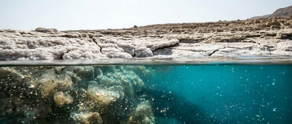
Ancient Lake Lisan The Dead Sea is the shrunken remnant of a much larger ancient lake called Lake Lisan, which existed from approximately 70,000 to 12,000 years ago (Stein, 2001). At its maximum extent around 26,000 years ago, Lake Lisan’s surface was approximately 200 meters higher than today’s Dead Sea, stretching far beyond the current shoreline. Lake Lisan was significantly less salty than today’s Dead Sea because its larger volume meant more dilution from the Jordan River and other inflows. As climate shifted at the end of the last Ice Age, increased evaporation caused the lake to shrink. The Jordan River’s inflow could not keep pace with water loss, so the lake contracted and salinity increased as minerals concentrated.
Evidence of ancient Lake Lisan is visible in the distinctive white layered sediments (called \”Lisan Formation\”) exposed along the Dead Sea’s margins. These layers, alternating light and dark bands, record seasonal variations in the ancient lake and serve as valuable climate records. Seventy thousand years of climate data, written in sediment.
How Salinity Developed
The Dead Sea’s extreme salinity, 34.2% or approximately ten times ocean levels, developed because the basin has no outlet. Water enters through the Jordan River, seasonal streams, and underground springs. The only exit is evaporation. When water evaporates, it leaves minerals behind. Over thousands of years, this process concentrated dissolved minerals to extraordinary levels. The specific mineral composition reflects the geology of the surrounding drainage basin. Water flowing through ancient marine sediments, volcanic rocks, and various geological formations picks up different minerals, which ultimately accumulate in the Dead Sea. The result is a unique mineral profile dominated by magnesium chloride rather than the sodium chloride that dominates ocean water.
The Dead Sea\'s 34.2% salinity developed because this closed basin has no outlet to the ocean; over thousands of years, water from the Jordan River evaporated while dissolved minerals accumulated, concentrating magnesium, calcium, and potassium to levels 10 times higher than any ocean on Earth.
FAQs
Is the Dead Sea getting deeper from tectonic activity?
Yes, very slowly.
Tectonic subsidence continues at a few millimeters per year. However, the dramatic recent changes (approximately 1 meter per year of water level drop) result from water diversion and evaporation, not tectonics. The tectonic deepening is imperceptible on human timescales.
Could an earthquake affect the Dead Sea?
The Dead Sea Transform is seismically active, and significant earthquakes have occurred historically in this region. Large earthquakes could theoretically affect the lake and surrounding infrastructure, but would not fundamentally change the lake’s existence. The basin is a stable, long-term geological feature.
Was the Dead Sea ever connected to the ocean?
The region was covered by ancient seas millions of years ago (like the Tethys Sea), but the current Dead Sea basin formed as a landlocked depression. The Dead Sea has been isolated from the Mediterranean and Red Sea throughout its existence as a distinct lake.
How old is the Dead Sea?
The Dead Sea Transform fault system began forming approximately
20 million years ago, with the specific pull-apart basin that houses the modern Dead Sea forming roughly 3 million years ago. The current lake, as the successor to Lake Lisan, has existed in roughly its present form for about 12,000 years. The extreme salinity developed over the most recent several thousand years as the lake contracted.