Background and Geological Context
Geography and Hydrology of the Dead Sea
The Dead Sea is a hypersaline terminal lake situated in the Jordan Rift Valley between Israel, Jordan, and the West Bank. It occupies the lowest exposed land surface on Earth, sitting at approximately 439 meters below sea level according to historical benchmarks, though current measurements place the water surface closer to 440 meters below sea level. The lake extends approximately 50 kilometers in length and 15 kilometers in width, bordered to the west by the Judean Desert and to the east by the Moab Mountains of Jordan.
A terminal lake has no surface outlet. All water that enters the Dead Sea basin can only leave through evaporation. The lake’s water balance is therefore determined entirely by the ratio of inflow to evaporative loss. Under natural climatic conditions, inflow from the Jordan River, numerous perennial springs, and seasonal runoff maintained a rough long-term equilibrium. That equilibrium has been substantially altered over the past century by human interventions affecting both inflow and extraction.
The Dead Sea is divided into two distinct basins. The deeper northern basin, with depths reaching approximately 300 meters, remains a continuous body of water and is the hydrologically significant natural lake. The shallower southern basin, historically connected to the northern basin in wetter periods, has been entirely converted to industrial evaporation ponds since the 1980s and no longer functions as a natural water body. All hydrological monitoring and water level measurements pertain to the northern basin.
The Dead Sea water level is controlled by a single variable: the ratio of freshwater inflow to evaporative loss. Under pre-20th-century conditions, the Jordan River delivered an estimated 1.3 billion cubic meters per year to the basin. Current estimates place actual inflow to the Dead Sea from all sources at approximately 100 to 200 million cubic meters per year, a reduction of more than 85% from historical baselines.
Historical Water Level Baseline
Systematic monitoring of Dead Sea water levels began in the late 19th century and accelerated during the British Mandate period in the 1920s and 1930s. The most commonly cited historical reference point is approximately 390 meters below sea level in 1930. Prior to significant human intervention, water level fluctuations occurred within a relatively narrow band governed by multi-year precipitation cycles rather than sustained directional trends.
Documentary records, historical maps, and geological evidence suggest that the lake’s water level has fluctuated by tens of meters over geological and historical timescales due to shifts in regional climate, tectonic activity, and natural hydrological variability. The current sustained decline is, however, unprecedented in the context of recorded human observation and is broadly attributed by the scientific community to anthropogenic factors rather than natural variability.
Key Developments: Phases of Water Level Decline
Phase 1 (1930 to 1973): Gradual Initial Decline
From the 1930s through the early 1970s, the Dead Sea water level declined at a measured rate of approximately 17 centimeters per year. During this period, the primary driver was the incremental expansion of water diversion infrastructure along the Jordan River system. Israel’s National Water Carrier, completed in 1964, redirected water from the Sea of Galilee (Lake Kinneret) southward for agricultural and municipal use, substantially reducing the volume of water reaching the lower Jordan River and the Dead Sea. Syria and Jordan simultaneously increased extraction from the Yarmouk River, the Jordan River’s main tributary, for irrigation.
The combined effect of these diversions reduced the Jordan River’s flow from an estimated historical average of over 1.3 billion cubic meters per year to a fraction of that volume. By the 1970s, the lower Jordan River had been reduced in most seasons to a shallow, heavily salinized stream carrying primarily agricultural runoff and treated wastewater rather than meaningful freshwater inflow to the Dead Sea.
Phase 2 (1973 to 2001): Accelerating Decline
Between 1973 and 2001, the rate of decline increased measurably as both freshwater diversion continued and industrial extraction from the lake itself intensified. ICL Dead Sea Works on the Israeli side and Arab Potash Company on the Jordanian side both expanded operations significantly during this period. The southern basin was fully converted to industrial evaporation ponds, removing it from the natural hydrological cycle entirely. Brine pumped into the southern basin for mineral extraction evaporates there rather than remaining in the northern basin, contributing directly to volume loss.
A significant hydrological event occurred during the winter of 1978 to 1979. For centuries, the Dead Sea had maintained permanent chemical stratification (meromixis), with distinct upper and lower water masses that did not mix. Reduced Jordan River inflow had progressively increased the salinity of the upper water layer until it approached the density of the fossil brine below. In winter 1978 to 1979, the first complete vertical mixing (holomixis) in centuries occurred. The lake subsequently oscillated between meromictic periods (1980 to 1983, 1992 to 1995) and holomictic periods, fundamentally altering its physical chemistry in ways that continue to be studied.
Phase 3 (2001 to Present): Exceeding 1 Meter Per Year
Since 2001, the rate of water level decline has accelerated significantly, averaging approximately 0.9 meters per year and frequently exceeding 1 meter in individual years. Monitoring data from 2025 places the water surface at approximately 439.78 meters below sea level, compared with roughly 418 meters below sea level in 2001, a total drop of approximately 21.78 meters over 24 years. Industrial water extraction for potash and chemical production by operations on both the Israeli and Jordanian sides accounts for a significant portion of this loss, alongside reduced freshwater inflow from the Jordan River.
The acceleration of decline reflects the compounding of multiple factors: continuing freshwater diversion, growing industrial extraction, and increasing regional temperatures associated with climate change. It is worth noting that as the Dead Sea shrinks, its absolute surface area decreases and the rising brine concentration lowers vapor pressure, both of which naturally reduce the total volume of water lost to evaporation. These physical braking mechanisms have, however, been insufficient to offset the massive deficit in freshwater inflow and the volume removed by industrial extraction. The net result remains a sustained decline.
Industrial operations currently extract approximately 3.8 million tons of potash, 200,000 tons of bromine, 45,000 tons of caustic soda, and 25,000 tons of magnesium metal annually, with the associated brine extraction and evaporation contributing approximately 280 million cubic meters per year to overall water depletion. These figures are sourced from project research documentation; readers requiring exact current figures should consult the most recent annual reports published by ICL Dead Sea Works and Arab Potash Company.
The Dead Sea has declined from approximately 390 meters below sea level in 1930 to approximately 440 meters below sea level by the mid-2020s, a net drop of nearly 50 meters over nine decades. The rate of decline accelerated from roughly 17 centimeters per year in the mid-20th century to over 1 meter per year since 2001, driven by reduced freshwater inflow and industrial brine extraction.
Documented Secondary Effects
The receding water level has produced a range of observable secondary effects across the Dead Sea basin. Along the western (Israeli) shoreline, more than 6,000 sinkholes have been recorded according to recent monitoring data, a consequence of subsurface salt dissolution where freshwater from springs or rain infiltration contacts former lakebed salt deposits. The sinkhole hazard has prompted road closures, resort area modifications, and access restrictions in multiple sections of the western shoreline.
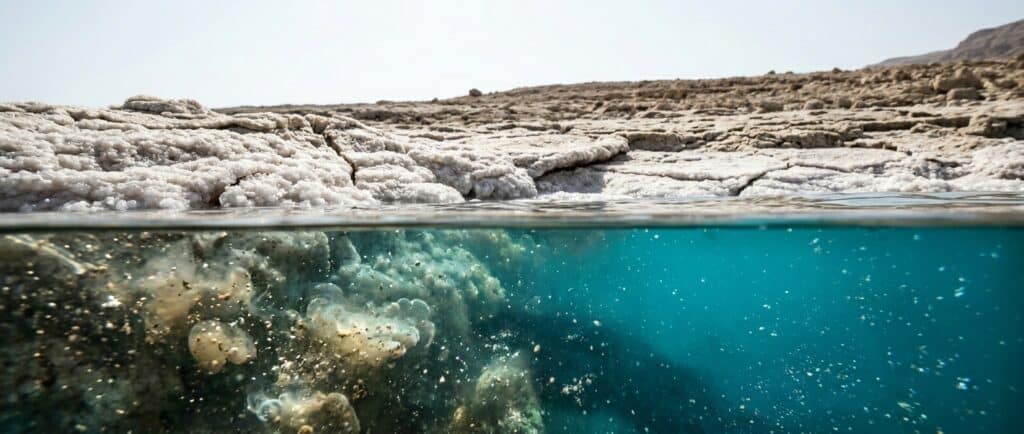
The exposed former lakebed terrain carries substantial salt crust formations, salt pillar structures, and crystalline deposits that represent decades of accumulated evaporative deposition. While these formations have become notable geological features and subject to visitor interest, they also indicate the extent of land that was submerged within living memory. Historical photographs taken as recently as the 1980s document shoreline access points that are now hundreds of meters from the current water’s edge.
Salinity has increased correspondingly. Concentrations rose from approximately 225 grams per kilogram in the 1950s to approximately 342 grams per kilogram by 2011, an increase of roughly 52% within six decades (Khlaifat et al., 2020). The continuing concentration of the brine is expected to reach the saturation point for additional mineral species progressively, potentially altering both the industrial chemistry of extraction operations and the character of the water as a therapeutic and recreational resource.
Stakeholder Positions
State of Israel
Israel operates the National Water Carrier, which diverts water from the Sea of Galilee to support agricultural and municipal supply across the country. Israeli authorities have consistently framed this infrastructure as essential to national water security given regional aridity and population growth. The Israeli government has participated in various international studies and negotiations regarding Dead Sea water levels, including feasibility assessments of the Red Sea to Dead Sea conveyance concept.
ICL Dead Sea Works, the Israeli industrial operator, is a major employer and export earner for Israel, with operations deeply integrated into the national economy. The company’s mineral extraction activities are acknowledged as a contributor to water volume loss, and ICL has engaged in environmental monitoring and reporting programs in connection with its operations.
Hashemite Kingdom of Jordan
Jordan faces acute water scarcity, ranking among the most water-stressed countries in the world by per-capita availability. The Yarmouk River, historically the Jordan River’s main tributary, has been substantially diverted for Jordanian agriculture and the growing population of Amman and the northern highlands. Jordan’s position on Dead Sea water levels is shaped by competing domestic water needs, economic interests in both mineral production through Arab Potash Company and in Dead Sea tourism, and stated environmental commitments.
The Jordanian government has been a proponent of the Red Sea to Dead Sea conveyance project and signed a memorandum of understanding with Israel and the Palestinian Authority in 2013 to advance feasibility work. Jordan has also engaged in bilateral water-sharing agreements with Israel, including provisions for increased freshwater transfers in the 1994 Wadi Araba Peace Treaty, though the volumes involved are not sufficient to materially affect Dead Sea water levels.
Palestinian Authority
The Palestinian Authority represents population centers and communities in the West Bank that have a stake in Jordan River and Dead Sea outcomes, though direct operational control over relevant water infrastructure is limited. Palestinian water access from the Jordan River has been constrained by existing allocation arrangements, and Palestinian representatives have raised the issue of equitable access to the river’s historical flow in various international forums. The Palestinian Authority was a signatory to the 2013 memorandum of understanding on the Red Sea to Dead Sea project.
Scientific and Environmental Research Community
Research institutions including the Hebrew University of Jerusalem, the Geological Survey of Israel, the Royal Scientific Society of Jordan, and numerous international academic partners have produced the most detailed and systematic documentation of Dead Sea water level trends and their consequences. The scientific consensus on causation is unambiguous: the primary drivers are anthropogenic freshwater diversion and industrial extraction, with climate change as a secondary contributing factor that is expected to intensify over coming decades through reduced precipitation and increased evaporation in the Jordan Valley region.
Environmental organizations operating across the region have consistently called for expanded Jordan River restoration, binding international agreements to regulate extraction, and the cessation or substantial reduction of industrial brine diversion to southern basin evaporation ponds. These positions are advocated without direct political authority but have influenced the framing of the issue in international environmental discussions.
Industrial Operators: ICL Dead Sea Works and Arab Potash Company
The two primary industrial operators have publicly acknowledged their role in the water budget of the Dead Sea and have participated in technical working groups and environmental impact studies. Both have framed their operations in the context of providing strategically important minerals (potash as agricultural fertilizer, bromine for industrial and pharmaceutical applications, magnesium for manufacturing) with limited substitution options. Neither company has proposed a fundamental restructuring of operations. Their participation in environmental discussions has been constructive at the technical level, though binding operational changes have not resulted from those discussions as of the time of writing.
Strategic and Environmental Implications
Hydrology and Chemistry
If current trends continue without intervention, Dead Sea brine will progressively approach saturation for additional mineral species beyond halite. The increasing concentration affects the density, viscosity, and thermal properties of the water, with potential consequences for the famous buoyancy effect that underpins recreational use. The therapeutic mineral concentrations for which the Dead Sea is internationally known would technically intensify, but the practical accessibility of the lake for bathing may be affected by continued shoreline retreat and the expansion of unstable sinkhole terrain.
The most significant hydrological legacy of the 1978 to 1979 overturn is the irreversible destruction of the ancient fossil brine layer that previously occupied the lower depths, characterized by elevated hydrogen sulfide concentrations and distinct trace element chemistry accumulated over centuries of stratification. That specific water mass mixed irreversibly into the upper lake during the overturn. The lake continues, however, to periodically re-establish temporary meromixis following exceptionally wet winters before returning to a holomictic state, confirming that the capacity for stratification itself has not been permanently eliminated. What was irreversibly lost was the ancient fossil brine, not the broader limnological possibility of stratification.
Tourism and Economic Impacts
Dead Sea tourism supports a significant regional economy on both the Israeli and Jordanian sides, encompassing hotel infrastructure, wellness and spa facilities, and associated services. The retreating shoreline has required substantial adaptation by resort operators, including the construction of pipes to pump water to pools and beach areas, and the abandonment or relocation of older shoreline infrastructure. In several documented cases, facilities that were operational within the past two decades are now stranded well inland of the current waterline.
The long-term viability of Dead Sea tourism as currently configured depends on either stabilizing water levels or sustained engineering intervention to maintain water access for visitors. Neither outcome is currently guaranteed by existing policy commitments. Tourism authorities on both sides have noted the issue as a strategic concern but have not significantly curtailed investment in shoreline facilities.
The Red Sea to Dead Sea Conveyance Project
The most extensively studied large-scale remediation proposal was the conveyance of water from the Red Sea northward through Jordan to the Dead Sea, with the dual purpose of desalinating some of the water for Jordanian consumption and releasing brine into the Dead Sea to partially offset the water deficit. A World Bank-led feasibility study published in 2013 assessed multiple route options and estimated that a pipeline of sufficient capacity could deliver between 1 and 2 billion cubic meters of water per year to the Dead Sea. The study also identified material geochemical risks, including the potential for gypsum precipitation that could alter the visual character of the water and the introduction of non-native microorganisms.
The project was officially canceled by Jordan in June 2021 following sustained diplomatic stalemates and the failure to secure adequate financing. Jordan subsequently shifted its water security strategy toward a purely domestic solution: the Aqaba to Amman Water Desalination and Conveyance Project, which draws on Red Sea desalination capacity for domestic water supply without routing brine to the Dead Sea. The bilateral Red Sea to Dead Sea conveyance concept is, for practical purposes, defunct. No successor framework with equivalent scope had been proposed or entered multilateral negotiation as of early 2026.
Alternative or complementary proposals have been advanced at smaller scale, including Jordan River restoration through the reduction of agricultural diversion and the return of treated wastewater to the river channel. EcoPeace Middle East (formerly Friends of the Earth Middle East), an environmental NGO operating across the region, has documented the ecological condition of the lower Jordan River and advocated for a restoration target of approximately 400 million cubic meters per year, a fraction of the historical flow but potentially meaningful at the margin.
No currently funded or politically committed project is capable of reversing or halting the Dead Sea water level decline in the near to medium term. The Red Sea to Dead Sea conveyance project, the most extensively studied large-scale option, was effectively abandoned following Jordan's formal withdrawal in 2021. Stabilization would require either a fundamental restructuring of Jordan River water allocation across three sovereign states or an alternative large-scale engineering intervention. Neither outcome has a binding implementation timeline as of early 2026.
Climate Context
The broader climate trajectory for the Jordan Valley region projects increasing aridity, higher temperatures, and reduced precipitation over the coming decades according to multiple regional climate modeling efforts. These trends are expected to increase evaporation from the Dead Sea surface and reduce natural inflow from precipitation-fed springs and seasonal runoff, adding a climate-driven component to the water deficit that would persist even if anthropogenic diversions were reduced. The Intergovernmental Panel on Climate Change (IPCC) regional assessments for the Middle East and North Africa have consistently identified the Jordan Valley as among the areas most vulnerable to projected hydroclimatic change.
Water Level and Salinity: Key Data Points
| Year / Period | Water Level (m bsl) | Salinity (g/kg) | Annual Decline Rate | Notes |
|---|---|---|---|---|
| Pre-1900 baseline | approx. 395 to 400 | approx. 200 to 215 | Variable (natural) | Historical reconstruction; limited direct measurement |
| 1930 | approx. 390 | approx. 215 to 225 | ~17 cm/year begins | Modern monitoring reference point |
| 1950s | approx. 393 | approx. 225 | Moderate (~17 cm/year) | Khlaifat et al. salinity baseline; verify exact figure against historical monitoring records |
| 1964 | approx. 395 (pre-carrier) | N/A | Increasing | Israeli National Water Carrier operational |
| 1978 to 1979 | approx. 399 | Upper layer rising | Accelerating | First complete holomixis event in centuries |
| 1980s | approx. 407 to 415 | Increasing | Accelerating | Southern basin converted to industrial ponds |
| 2001 | approx. 418 | Increasing | Exceeds 1 m/year | Rate of decline benchmark change |
| 2011 | approx. 427 | 342 | >1 m/year | Khlaifat et al. salinity measurement; 52% increase from 1950s |
| 2025 | approx. 439.78 | Continuing increase | >1 m/year | Project research data; verify against current monitoring |
Note: water level figures expressed as meters below sea level (m bsl). All values approximate; historical figures carry measurement uncertainty. The 2025 figure is sourced from project research documentation and should be verified against current Israel Hydrological Service or Jordan Valley Authority monitoring records before publication.
FAQs
How much has the Dead Sea water level dropped?
The Dead Sea water level has declined nearly 50 meters since 1930, from approximately 390 meters below sea level to approximately 440 meters below sea level by the mid-2020s. The rate of decline accelerated from roughly 17 centimeters per year in the mid-20th century to over 1 meter per year since 2001. This represents one of the most extensively documented cases of terminal lake water level decline on record.
What is causing the Dead Sea to shrink?
The two primary causes are the diversion of the Jordan River (historically the Dead Sea’s main freshwater source) for agricultural and municipal use by Israel, Jordan, and Syria, and the extraction of brine by industrial mineral producers on both sides of the lake. These diversions have reduced inflow to a small fraction of historical volumes. Secondary factors include increasing regional evaporation linked to climate change, though this is considered a smaller contributor than direct human water management.
Will the Dead Sea disappear entirely?
Under current trajectories, the Dead Sea would not “disappear” in the sense of complete desiccation within any near-term projection period, because the rate of evaporation decreases as brine becomes more concentrated and because the deepest portions of the northern basin provide substantial water volume. However, the lake would continue to shrink, its surface area would decrease, its shoreline would continue to retreat, and the character of the water body would change substantially. Long-term scenarios published by the scientific community suggest stabilization at a lower level if current trends persist, though the timeline and elevation of that equilibrium are uncertain.
Is there a plan to save the Dead Sea?
The Red Sea to Dead Sea conveyance project, which would have piped water from the Red Sea northward through Jordan with partial desalination and Dead Sea discharge, was the most extensively studied large-scale option. A World Bank feasibility study assessed it positively in 2013, but Jordan formally withdrew from the project in 2021 due to diplomatic and financing failures, and subsequently redirected its water security investment to a domestic desalination pipeline. With the conveyance project effectively defunct, the remaining alternatives are Jordan River restoration, for which current efforts remain far below the required volume, and smaller-scale technical interventions. No funded project capable of reversing or stabilizing the water level has an implementation timeline as of early 2026.
What are the dangers of the Dead Sea sinking?
The primary immediate dangers are the formation of sinkholes along the western shoreline (more than 6,000 have been recorded according to recent monitoring data), which pose direct hazards to infrastructure and visitors. Broader consequences include the retreat of resort and recreational facilities from the shoreline, the loss of previously accessible beach areas, reduced tourism economic activity, and the long-term change in the water’s chemical character as salinity continues to increase. The sinkhole risk is considered the most acute near-term safety concern for the Ein Bokek resort area and surrounding western shoreline.
Does the Dead Sea water level affect the floating experience?
The buoyancy that enables effortless floating is a function of brine density, which increases as concentration rises. As the Dead Sea becomes more saline, the brine technically becomes denser and the buoyancy force increases. The floating experience itself is not threatened by water level decline in a direct physical chemistry sense. The practical challenge is the retreating shoreline: access to the water’s edge at established beach and resort areas requires engineering adaptation (such as pumping systems) to maintain visitor access as the natural shoreline moves progressively further from historic access points.